Active Weather By Mid Week. Very Windy! Severe Thunderstorm Potential?
- Metro Weather Watch

- Nov 25, 2019
- 2 min read
Good Morning to all of our wonderful facebook fans out there! Hope everyone has a great start to this Thanksgiving week. Some of us will have a short work week and I'm sure you are looking forward to that. I want to apologize to our fans out there, because I have not been able to do these forecast blogs for the last week, due to increased work at my day job. I found a window of opportunity, so lets jump right into it!
A strong area of low pressure will move into the region and affect the area by late Tuesday into Wednesday. Showers and Thunderstorms are forecast to move through the region. At this time, any severe threat looks conditional. This will be a VERY windy system.
The 06z run of the NAM 12 km model brings some showers into the lower Ohio Valley region Tuesday afternoon. Showers and possibly some thunderstorms Tuesday night into early Wednesday morning. The NAM 12 km does not look to excited about any strong or severe activity, but that does not mean there won't be any isolated activity.

The high resolution NAM 3 km is a bit more aggressive. It brings showers and possibly and possibly some scattered stronger storms in two potential rounds through the Evansville Metro/Tri-State and southeast and eastern areas of our coverage zone in the Bowling Green and Louisville, Kentucky areas Tuesday night into Wednesday morning.

Current SPC Convective Outlook has a Marginal Risk well to the southwest of our region on Tuesday. This could change in later outlooks and possibly include parts of our region Tuesday night into Wednesday morning. Isolated damaging winds and hail are the main potential hazards in the Marginal Risk area. The tornado threat is low, but not zero. The lighter shade of green is just general non-severe storms, which, at this time come up to the Wabash River.

Although the severe potential in our region remains low, at this time. Some of the ingredients for severe weather will be present. Bulk shear is very impressive. In fact, NAM 12 km has it at 90 knots to 100 knots.

Wind and Height are another key ingredient and the NAM 12 km has it maxed out and off the charts at 100 kt to 130 kt across the coverage area.

CAPE (instability) is just enough to support at least a wind threat, with already gusty surface winds forecast (NAM 3 km).

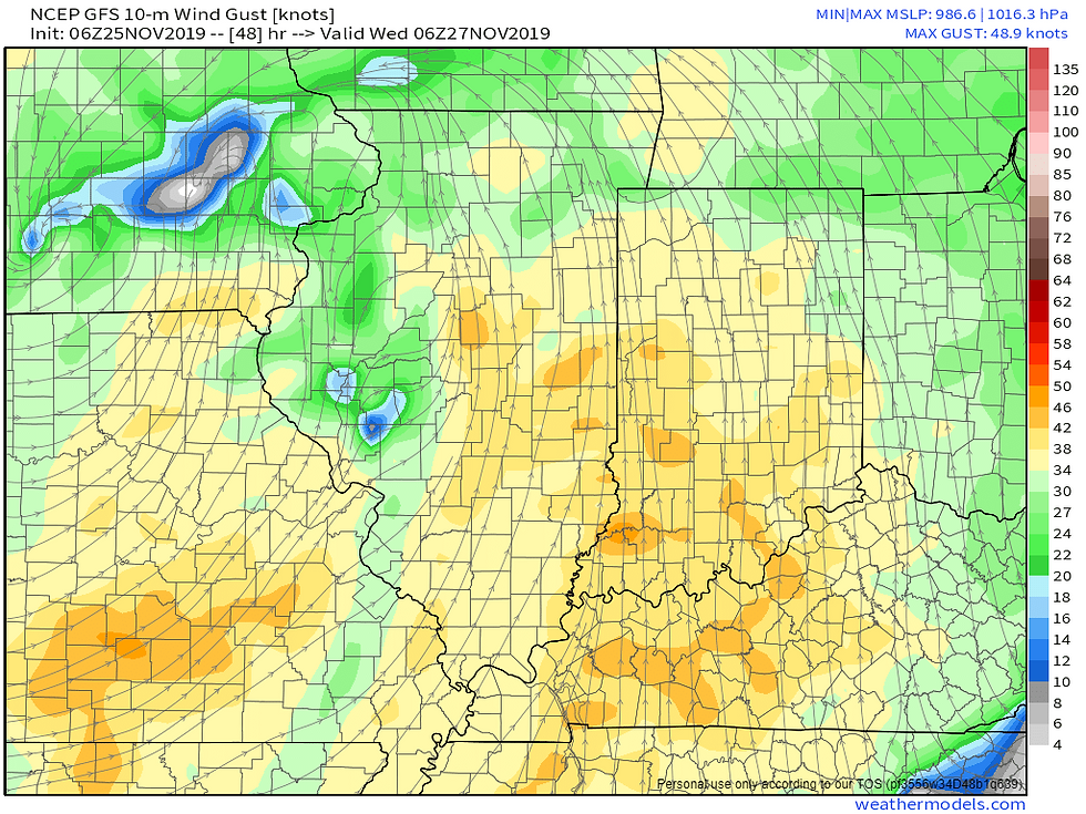
Wind gust will be the bigger concern. I think we will see Wind Advisories and possibly High Wind Warnings issued for most of the region Wednesday afternoon and evening. The NAM-WRF is showing gust over 50 mph. Would not be surprised to see some gust approach or exceed 60 mph, especially if stronger convection occurs.

GFS shows wind gust between 40-50 mph.

The ECMWF (European Model) shows wind gust between 40-50 mph.

Well that's going to do it for this blog. We will keep you updated on winds and possible storms for mid week. Have a great day!


Comments