Long Range Outlook (2/7/20 – 2/10/20)
- Metro Weather Watch

- Jan 28, 2020
- 3 min read

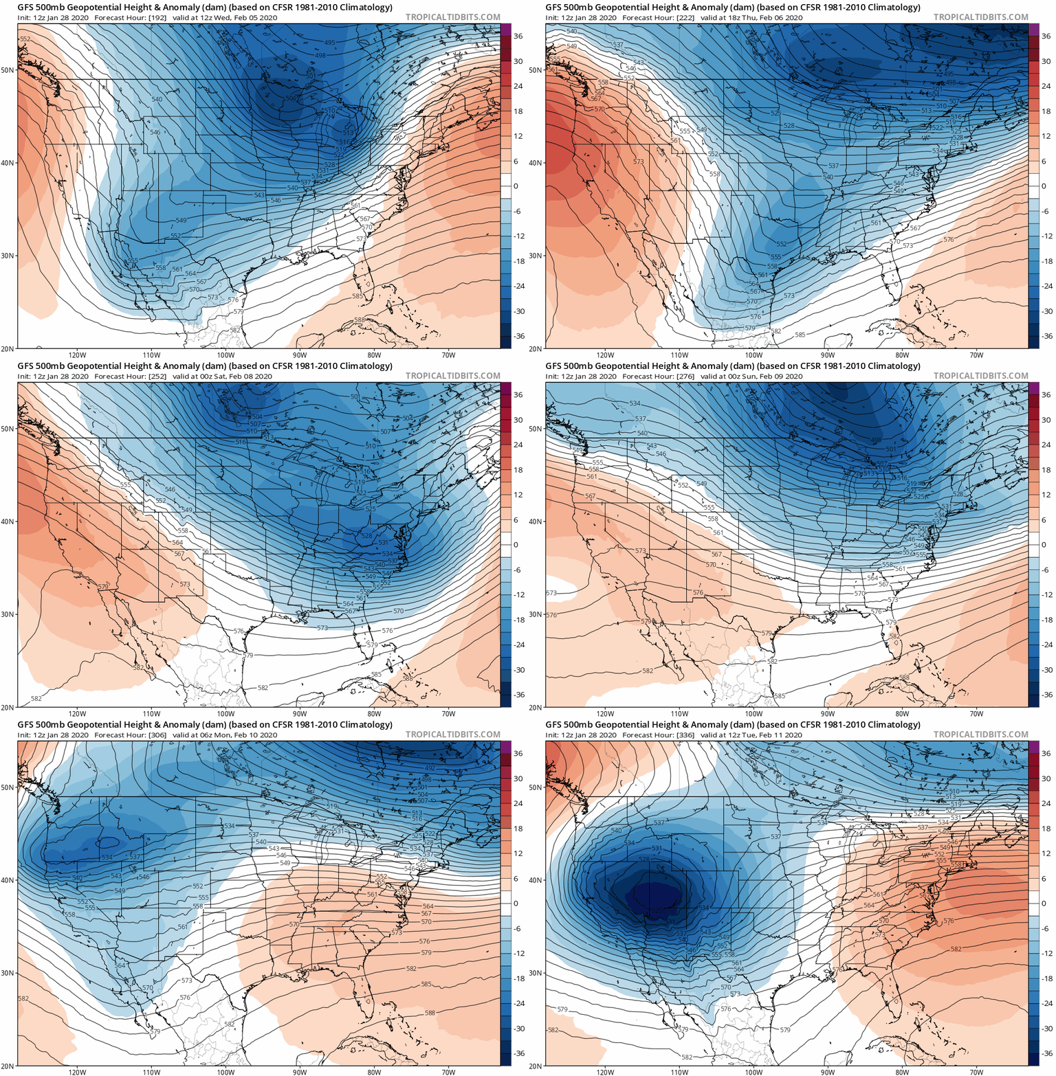
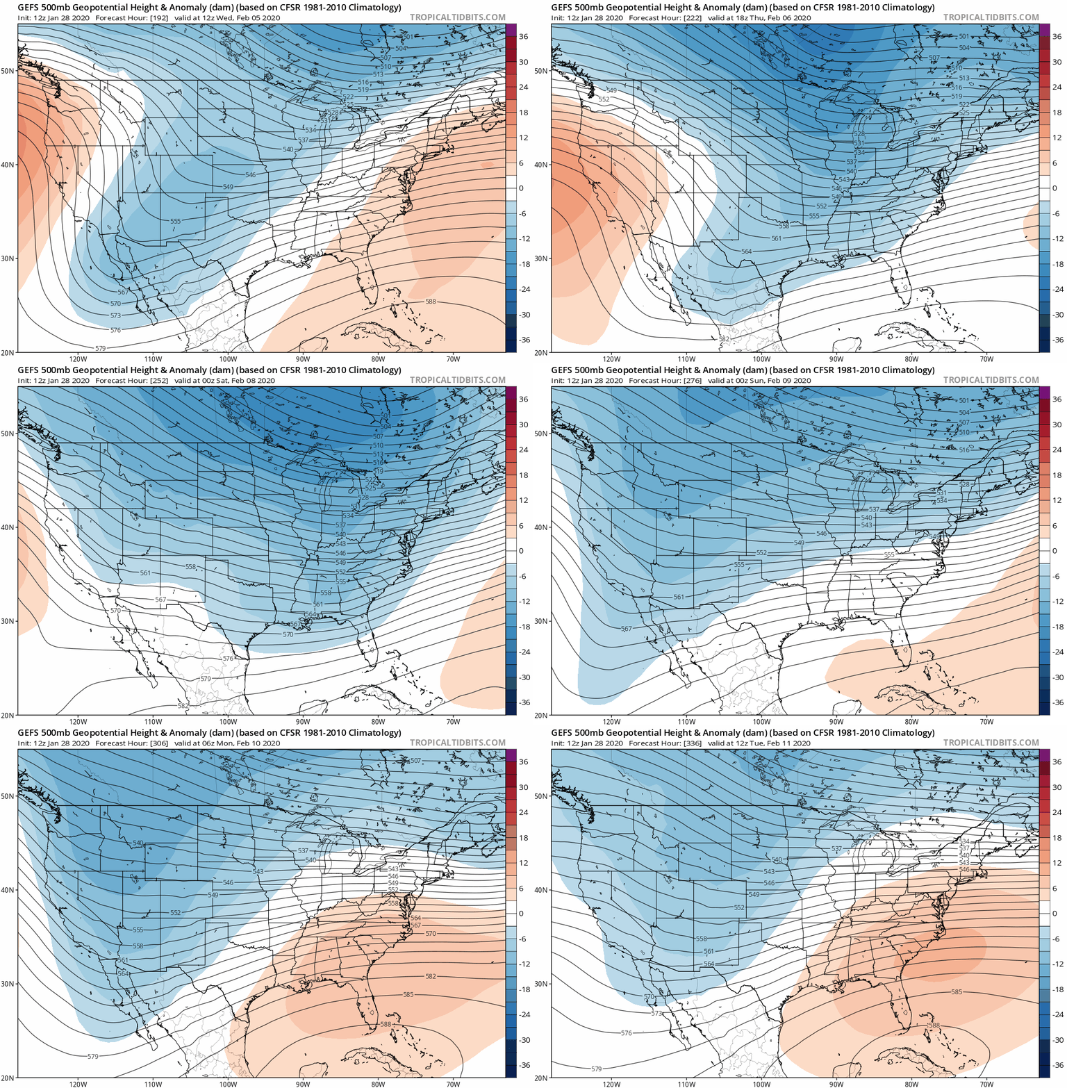
Early to mid-February continues to show a shift towards cold temperatures. The last Extended Forecast post touched on this subject, and models at the time thought it would be this week into the weekend. I was off with temperatures due to constant warming from the gulf and being on the warm side of Low systems. Thus, current models seem to push it off into next week. After looking at the recent GFS, and GEFS anomalies, a cold sector is definitely seen to pass through next week.
Notice that from looking at both anomalies, this cold sector looks to be a longwave slowly entering with multiple shortwaves. This will spark the 4 corners (Utah, Colorado, New Mexico, Arizona) to have a Low be able to form on the West Coast. You will definitely notice it on the GFS because of the darker cold spot at the beginning. According to the GFS, it seems to enter the Evansville Metro around Wednesday next week with rain being the main precipitation type. This is what will set up colder air across the entire area towards the end of next week until it is shifted north due to a well-developed Low system. With all of this in mind, what could next weekend look like?

Friday, Feb. 7 seem to have high temps around the 30s with low temps around the mid-20s. A potential chance of snow is possible across Southern Illinois/Indiana, and parts of Kentucky because of how quickly a short-lived Low system from the Northwest will be able to extend into the midwest. I’m guessing maybe less than an inch or two may fall, but keep in mind this is only a guess. Saturday, Feb. 8 looks to have high temps around the 40s with low temps in the mid-20s.

Recall I mentioned the colder air would shift away at some point due to a well-developed Low system. From observing the GFS model, that seems to be the case as it looks to happen between Sunday (Feb. 8) and Monday (Feb. 9). Sunday, Feb. 8 seems to have high temps in the mid-40s with lows in the upper 30s. It is noticeable Monday, Feb 9 seems to have high temps around the 50s with lows around the upper 40s. This shows signs we will once again be on the warm side before entering the cold. Rain will be the main precipitation type seen Sunday night into Monday morning but looks to stop during the afternoon. Winds should not pick up until later Monday night with moderate to maybe high severity.
In conclusion, cold weather will eventually enter the Evansville, Metro. Potential snow is possible at the end of next week, but I’m not completely sold on it yet. The main reason is the GFS seems to be slightly aggressive with temperatures and Low system placement/development when looking far into the future. When other models come into play, slight changes may occur with all of these things. That being said, what we are fairly confident about is the potential for cold weather during the beginning of February. Have a great day!
Meteorologist Sean Danaher
Keeping you informed at home or on the go!
Extended Forecast is sponsored by Hoosier Holistic. Located at 707 State St, Newburgh, Indiana 47630. Specializing in CBD products, health and beauty products, relaxation products, jewelry and more. For more information about their products, visit them on their Facebook page or give them a call today at (812) 217-1298.
We support local small businesses! Get your company recognized! For information on how you can become a sponsor and advertise your company logo on our weather graphics and reach thousands of potential customers, contact us at mwwadvertising1@gmail.com or send us a private inbox message.


Comments