LONG RANGE OUTLOOK (2/21/20 – 2/24/20)
- Metro Weather Watch

- Feb 11, 2020
- 3 min read

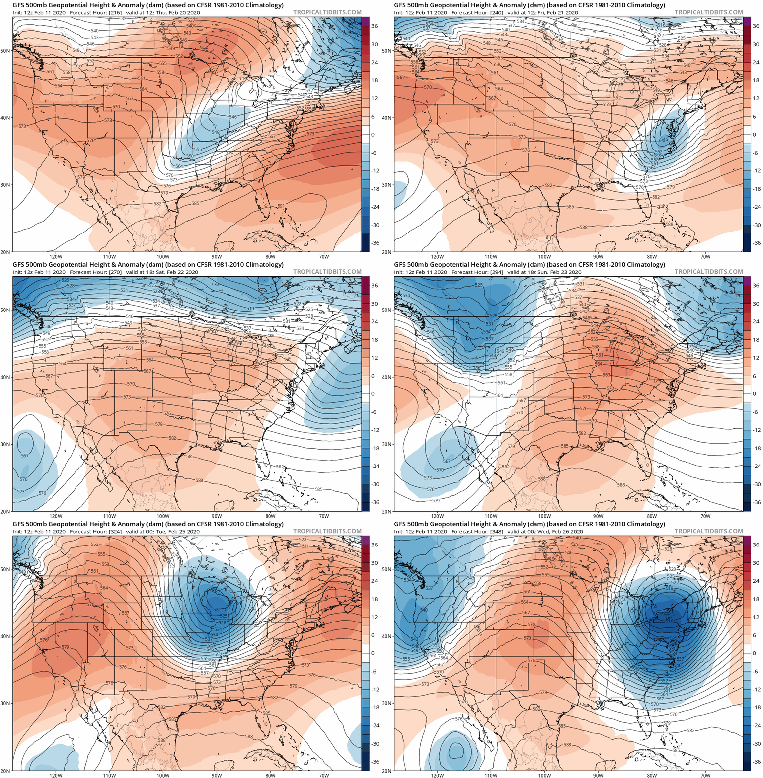
Is winter over yet? Cold weather is still trying to fight warmer air to sustain winter. We see this at the beginning of next week as the longwave enters the Midwest. Two Low systems will be associated with it bringing rain showers and possible marginal severity February 17 and 18. Flooding will likely be a concern too. One will be from the northwest while the other will be from the southwest. By the end of this system, cold weather will enter behind the system. What is interesting is the GFS has predicted the potential for snow Wednesday, Feb. 19. It will really depend on moisture and how quickly colder air enters the Evansville Metro. With all of this in mind, what could next weekend look like?

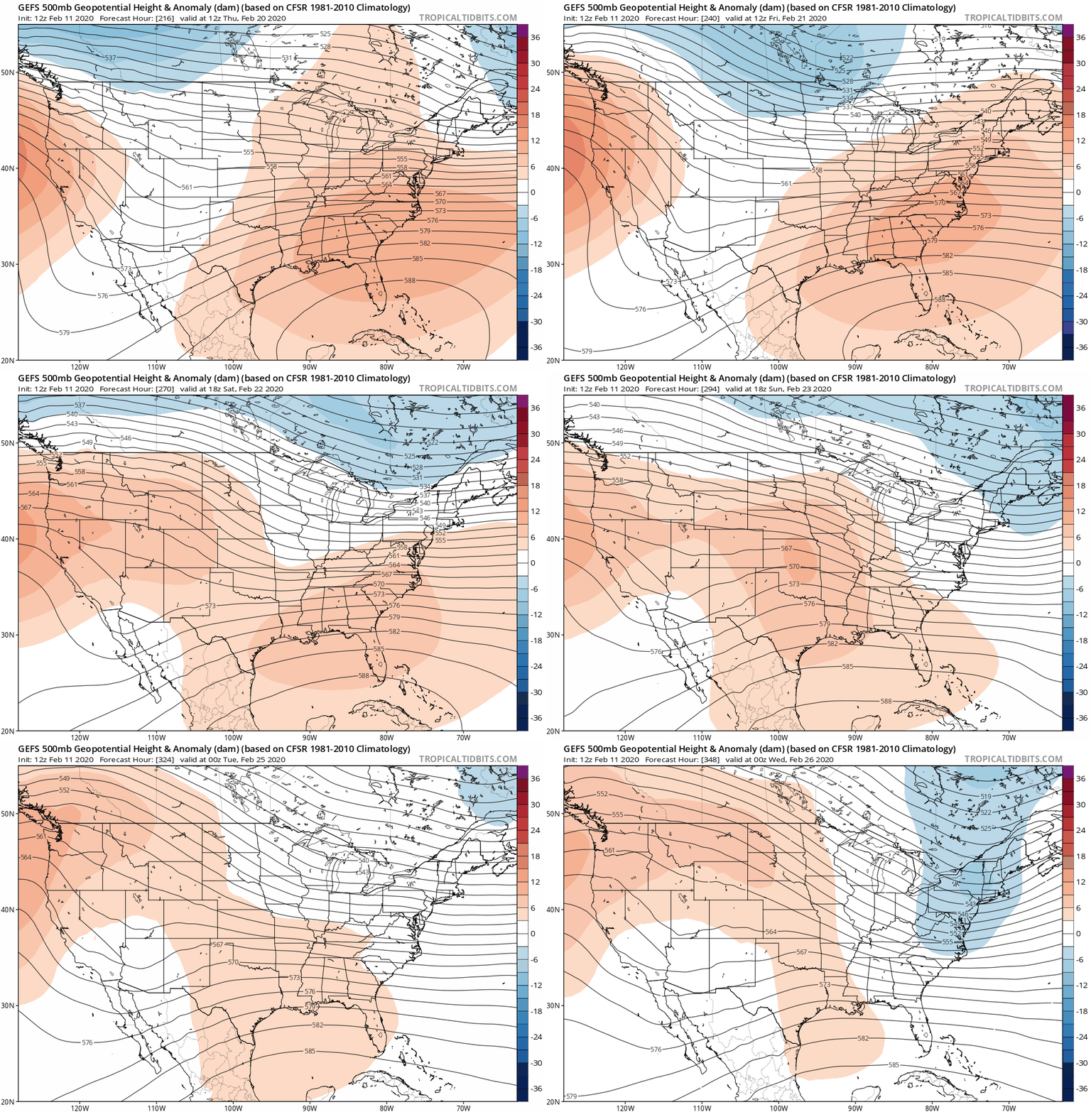
Friday, Feb. 21 could have high temps in the lower 40s with lows in the lower 30s. The reason is cold air stretches southwest the day before (Thursday, Feb. 20), then a ridge of warm air follows. Saturday, Feb. 22 may have high temps in the 50s with lows in the lower 30s. According to the GFS, this ridge of warm air entering continues throughout the rest of the weekend. Sunday, Feb. 23 could have high temps in the lower 50s with lows in the upper 20s. It does not seem to move away due to slow-moving High systems across the Midwest and East Coast. It will not be until Monday where a Low system over Canada will stir up potential moisture near the Great Lakes thus causing potential rain to fall around the afternoon. However, temperatures will not be affected immediately until Monday night. Thus, Monday, Feb. 24 may have high temps in the upper 40s with lows in the lower 40s.
In conclusion, there is not a whole lot to go off for next weekend. Any weather event seems to happen much earlier in the week with cold air settling by midweek. The prediction for any future snow will likely be an outlier as more models are incorporated later. Ensemble models are showing that warmer air may dominate with Low systems at the beginning and end of next weekend.
You definitely see this from the close contours and darker blue spots on the GFS rather than the GEFS anomalies. The GEFS does show this, but it is very subtle. Winter is not over! We just keep missing the potential for snow because of the lack of moisture behind Low systems. Furthermore, being on the warm side during the day does not help either because of temperatures increasing rapidly, then slowly decreasing as we enter the backside of each Low system. Overall, a few changes will be made as we get closer in time when more models are included. Have a good day!
Meteorologist Sean Danaher
Keeping you informed at home or on the go!
Long-Range Outlook is sponsored by Hoosier Holistic. Located at 707 State St, Newburgh, Indiana 47630. Specializing in CBD products, health and beauty products, relaxation products, jewelry and more. For more information about their products, visit them on their
Facebook page or give them a call today at (812) 217-1298.
We support local small businesses! Get your company recognized! For information on how you can become a sponsor and advertise your company logo on our weather graphics and reach thousands of potential customers, contact us at mwwadvertising1@gmail.com or send us a private inbox message.


Comments